The Eastern Marine Biology Research Center of the Fisheries Research Institute collaborated with Stanford University of the United States to use satellite remote sensing and recording technology to analyze the habitat temperature, depth, and geographic location of Thunnus orientalis, known as the "king of sashimi". This collaboration unraveled the mysteries of the breeding migration and ecological habits of Thunnus orientalis. According to the satellite data, Thunnus orientalis have significant differences in their daytime and nighttime displacement. They prefer to inhabit a thermocline within about 200 meters at night, while they mostly move in waters at a depth of 300 to 500 meters during the day. This research finding is the first global record of the breeding migration characteristics of Thunnus orientalis and can be used as an important reference for the assessment of fishery management resources.
The Fisheries Research Institute pointed out that there are three types of Bluefin tuna worldwide, namely, Thunnus orientalis, Thunnus maccoyii, and Thunnus thynnus. Specifically, Thunnus orientalis, which is widely distributed in the temperate waters of the Pacific Ocean, is the largest kind of Thunnus, with a maximum body length of over 4 m, a weight of 700 kg, and a lifespan of over 40 years. Thunnus orientalis reaches sexual maturity at the age of three, and there are two main breeding grounds. One is in the Philippine Sea in the northwest Pacific, which extends from Okinawa to the eastern waters of Taiwan where Thunnus orientalis spends the breeding season from mid-April to early July. The other breeding ground is the southern part of the Sea of Japan where Thunnus orientalis spends the breeding season from mid-June to early August.
Juvenile Thunnus orientalis hatched in the southern part of the Sea of Japan can follow two routes to migrate to the eastern Pacific Ocean. Specifically, they either travel northward crossing the Tsugaru Strait to the intersection area of the Oyashio Current and Kuroshio Current, or travel southward through the Matsu Strait between Japan and South Korea to the East China Sea, eastward along the coast of Japan to Kuroshio Current, then northward to the intersection area of the Oyashio Current and Kuroshio Current. Juvenile Thunnus orientalis of both groups will move towards the eastern Pacific Ocean along the Kuroshio Current. Juvenile Thunnus orientalis will experience one to two years of large-scale migration across the Pacific Ocean to Baja California for feeding and growth, then they will migrate across the Pacific Ocean and return to eastern Taiwan and the Sea of Japan in the northwest Pacific for breeding.
According to the Fisheries Research Institute, as the life span of Thunnus orientalis at different stages is utilized by different countries, the International Scientific Committee for Tuna and Tuna-like Specifications in the North Pacific Ocean (ISC) has been drafting fishery management measures since 2011. The 2022 ISC Assessment Report on Thunnus Orientalis Resources shows that although the population of breeding females has gradually increased in recent years, the overall resources are still in an overfished state and there are signs of persistent overfishing. After an evaluation by scientists, the Western and Central Pacific Fisheries Commission (WCPFC) confirmed that the main pressure causing resource decline is juvenile fish catching. In response to the evaluation of WCPFC, the Fisheries Research Institute indicates that Thunnus orientalis is a high economic species that is seasonally caught by small- and medium-sized longline fishing boats in Taiwan. The Thunnus orientalis caught in the eastern and southeast waters of Taiwan from April to June each year has reached the stage of sexual maturity (over 6 years old), which means that Taiwan mainly catches adult fish. Hence, it is an urgent task to conduct dynamic analyses on the population of adult fish.
The Fisheries Research Institute stated that in order to further understand the breeding migration characteristics and ecological habits of Thunnus orientalis, the Institute conducted a satellite tagging experiment. After five years of efforts, in May 2021, the Institute successfully deployed an ejection-type satellite tag recorder on each of three adult Thunnus orientalis (No. 202621, about 200 kg; No. 201097, about 300 kg; and No. 201098, about 180 kg). These tags recorded 53 days and 17 hours, 13 days and 4 hours, and 60 days and 16 hours, respectively, before being ejected. The cumulative recording time from the three tags was 127 days and 13 hours, and the recording range was from the offshore waters of eastern Taiwan, through Okinawa Island of Japan, to the southern waters of Hokkaido, with a linear movement distance of over 3,000 kilometers. Thunnus orientalis have significant differences in daytime and nighttime displacement, and the results show that they prefer to inhabit within a thermocline (about 200 m) at night, while they are most active in waters with a depth of 300 m to 500 m during the day.
The Fisheries Research Institute indicated that due to the large size and strong strength of adult Thunnus orientalis, there is a risk of disconnection from the longline fishing sets at any time during the process of hauling. Hence, it is quite difficult to guide living fish to the sea surface for configuring satellite tags. The Fisheries Research Institute would like to express sincere thanks to the Taitung Xingang Tuna Longline Fishing Vessel for their willingness to assist in this research despite modest subsidies. The results of this research can supplement the ecological information that regional fisheries management organizations lack in establishing resource assessment models and fulfill Taiwan's obligations as a Thunnus orientalis user country.
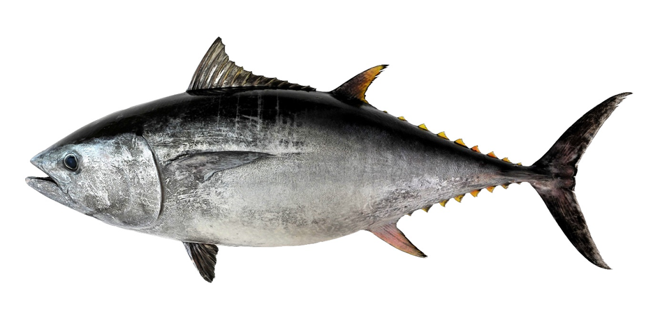
Figure 1. Thunnus orientalis
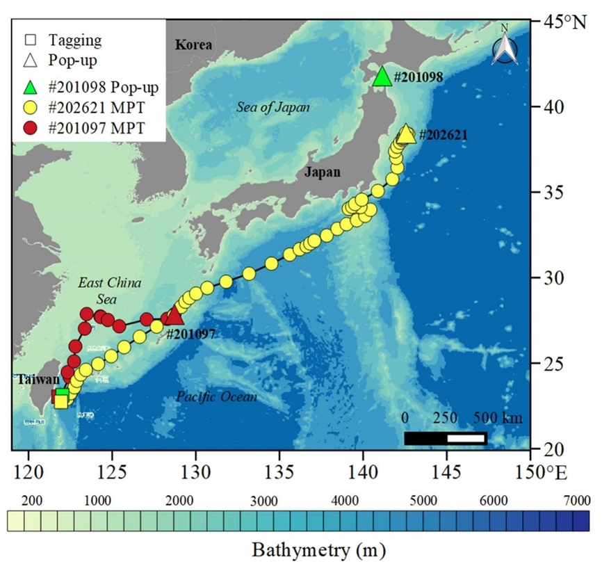
Figure 2. The Tag Release Locations of Three Thunnus orientalis (Yellow #202621, Red #201097, and Green #201098) in the Sea (Square), the Tag Ejection Locations of Fish Bodies (Triangle), and the Estimated Movement Paths (Red and Yellow Circles) (Note: The satellite data returned by Thunnus orientalis #201098 were insufficient to analyze the path data)
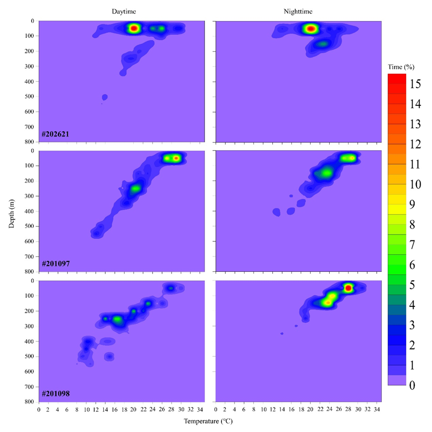
Figure 3. Depth and Temperature of the Daytime and Nighttime Hotspots of Three Tagged Thunnus orientalis (#202621, #201097, and #201098)